NBC have just released their draft Local Character Statements (app 6 months after they promised them). These are very important as they form the backbone of what is permitted in out local area. Please review these and take up the invitation from NBC to comment
You need to go onto this link for the proposal Refer Link
Proposed new character statement and the previous one are below
Proposed
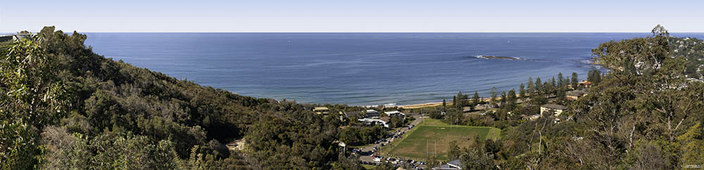
The area is characterised by low density residential development that is responsive to the dynamic, steep to sloping landforms from the ridgelines running north to south along the peninsula, down to the Pittwater
waterway. The strong visual connection to the Pittwater waterway affords the dwellings significant views to the western foreshore and to be visually prominent from the waterway. Slopes and ridge tops of the area are visually prominent. Extensive tree canopy with dense mature tree plantings provides sheltered and partly shaded positions, distinguishing it from the adjoining Coastal Peninsula area which is more exposed to the open ocean with relatively less canopy coverage.
Desired Future Character
• Protect the low density residential character of the area with future development sympathetic to the natural environment, integrated with the landform and landscape.
• Ensure that building heights are within the tree canopy and maintain views from below the tree canopy to Pittwater waterway.
• Maintain the scale of existing community-focused retail, community, and recreational facilities and ensure that functional land uses reflect the community’s needs and aspirations.
• Maintain Church Point as an important link to the offshore communities on Scotland Island and the western foreshores of Pittwater and maintain the operational capacity of working waterfront including slipways.
• Maintain existing vegetation levels and canopy trees with generous setbacks and retention of large lot sizes to support established and new plantings on private land.
• Ensure that development is designed to be safe from hazards, including minimising site disturbance on sloping lots, anticipating risk of coastal inundation and bush fire risks.
Character Elements
Natural environment
Topography and views • Steeply sloping to undulating land from the waterway to the ridgeline along the Peninsula.
• Predominantly escarpment with some plateau, headland, and valley areas.
• Views across Pittwater waterway are a defining feature of this character
area.
Biodiversity and tree canopy
• High vegetation cover both within lots and the streetscape with a significant presence of established trees contributing greatly to the overall character of the area.
• Extensive environmental values including numerous threatened species
and threatened ecological communities including littoral rainforest,
Pittwater Spotted Gum Forest, Coastal Saltmarsh Estuarine swamp oak
floodplain forest and swamp Sclerophyll Forest on coastal floodplains.
Natural features and hazards
• Estuarine inundation risk exists along most of the harbour foreshore area,
while pockets of bush fire prone land exist in more densely vegetated
pockets across the character area with flood risks along creeks and
streams.
Built form
Height and density • Predominantly low rise (1-2 storeys) low density suburban residential, single dwellings with limited medium density (generally 3-4 storeys) urban residential developments.
Building styles • Mixed architectural styles with majority post-war, contemporary, and site specific styles with occasional heritage buildings.
Lot size and block pattern
• Predominantly larger lot sizes (>900m2)
Street network • Predominantly organic road development pattern transitioning to modified grid with commonly occurring cul-de-sac and end roads.
Open Space • Harbour facing reserves around Pittwater include Bayview and Careel Bay.
Activity and uses
CONFIDENTIAL
Northern Beaches Council – Draft Local Character Areas and Statements – Community Group Review and Feedback
Land uses and community facilities
• Mostly suburban residential with some local and neighbourhood centres.
• Some open space reserves of various sizes for passive recreation
purposes. There is a strong connection to maritime recreation uses on the
Pittwater waterway.
Non-indigenous heritage and culture
• State heritage listed ‘Hy Brasil’ house. Locally listed Sandy Beach Jetty,
trigonometrical stations, a memorial obelisk, a sandstone retaining wall,
trees and World War II Tank Traps.
Aboriginal heritage and culture
• Although most of the area has low potential for Aboriginal sites due to land disturbance from residential development, there are recorded sites of shell middens, habitation shelters, art and engraving sites in this area with a high potential for unrecorded sites in bushland reserves, foreshore areas,
sandstone outcrops, platforms and cliff lines. There have been some
recorded sites on private residences. Sandy environments in the area have
a high potential for human remains.
Economic activity • Maritime industry features strongly with recreational activity enabled by working waterfront activity including marinas and slipways.
Transport and connectivity
• Accessible via the B-line and other limited local bus routes.
• High car-dependency.
• Church Point is an important connection to Scotland Island and the
western foreshores. Transport access and services are limited by
topography and low density.
• Constrained by steep topography with disconnected, sparsely occurring
footpaths and on-road and shared bicycle routes.
Previous Character Statement from Pittwater Council DCP
A4.10 NEWPORT LOCALITY
Land within the Locality
Land within the Newport Locality is identified on the Newport Locality Zone Map.
Context
The locality was occupied by farming settlements from the early 1800s, and was a port for coastal steamers in the latter part of the nineteenth century. The Newport Hotel built in 1880 attracted visitors from Manly by coach and Sydney by steamer. As the road improved and beach holidays became popular, Newport expanded. Until the 1950s, Newport remained
largely a holiday location with few permanent residents. Residential development and permanent occupation of dwellings increased from the 1950s.
Since this time, the locality has developed into a predominantly low-density residential area, with dwellings built along valley floor, plateau and slopes. The locality is characterised mainly by one and two-storey detached dwellings on 500-1,300 square metre allotments, increasing to 950-1,600 square metres on the plateau and slopes. The residential areas are
of a diverse style and architecture, a common thread being the landscaped, treed frontages and subdued external finishes. Medium-density housing adjoins the Newport Commercial Centre along Ocean and Foamcrest Avenues, and in pockets along Kalinya Road, Gladstone Street, Livingston Place, and Queens Parade.
The locality is serviced by the Newport Commercial Centre on Barrenjoey Road, north of Bardo Road and South of Coles Parade, and neighbourhood retail centre at Kalinya Street.
The locality also contains the Newport Primary School, Newport Surf Life Saving Club, Newport Surf Club, Newport Arms Hotel, Newport Anchorage, and recreational facilities including the Newport Bowling Club and several reserves.
Houses and vegetation in the vicinity of Burke Street, Bungan Head Road, Prince Alfred Parade, Queens Parade and Myola Road, indicative of early settlement in the locality, have been identified as heritage items.
The locality is characterised by the steep slopes to the north and south, and valley floor. Due to the topography, significant views can be obtained through all points of the compass.
Conversely, the slopes and ridge tops of the locality are visually prominent.
Substantial tree growth has been established, although the locality contains few natural reserves and bushland areas.
The natural features of the locality result in a high risk of bushfire, landslip, flood, coastal (bluff) hazard, and estuary wave action and tidal inundation.
The major roads within the locality are Barrenjoey Road, Prince Alfred Parade, Beaconsfield Street, Irrubel Road and Myola Road. Barrenjoey Road is the primary access road to the northern suburbs of Pittwater. Few pedestrian links and pathways exist within the locality.
Desired Character
The Newport Locality will remain primarily a low-density residential area characterised by one and two storey residences in a natural landscaped setting, interspersed by compatible land uses where appropriate. Dual occupancy development will generally be located on the valley floor and lower slopes, subject to environmental and other constraints. Mediumdensity
housing will concentrate within and adjoining the Newport Commercial Centre, neighbourhood 31 retail centre, and transport nodes where appropriate. The locality will continue to be serviced
by existing retail, community and recreational facilities.
Future development in the locality will be consistent with public infrastructure capacity and environmental constraints.
Future development will maintain a distinct height limit below the tree canopy, and reflect the predominant scale and setbacks of existing development. Buildings will be designed to address the street and/or waterway, integrate with the public domain, and be at a ‘human
scale’. Contemporary buildings will utilise façade modulation and/or incorporate shade elements, such as pergolas, verandas and the like. Building colours and materials will harmonise with the natural environment and not dominate it. Development on hillsides and in
the vicinity of ridge tops will integrate with the natural landscape and topography.
Future development within the Newport Commercial Centre will reflect the seaside-village character of the retail strip.
Heritage items indicative of early settlement in the locality will be conserved.
The indigenous tree canopy and vegetation will be retained and enhanced to assist development blending into the natural environment, and to provide Koala feed trees and undergrowth for smaller animals. The natural landscape, including rock outcrops, remnant bushland and natural watercourses, will be preserved.
Existing and new development will be made safe from natural hazards.
Vehicular, pedestrian and cycle access within and through the locality will be maintained and upgraded where appropriate.
Hazards, Natural Environment and Heritage
Hazards
The Newport Locality is affected by various hazards. Land affected in the Newport Locality is shown on the Hazard Map held in the offices of Council.
Natural Environment
The Newport Locality includes vegetation areas, threatened species, or areas of natural environmental significance. Land affected in the Newport Locality is shown on the Natural Environment Map held in the offices of Council.
Heritage
The Newport Locality may include Heritage items and/or conservation areas. Land affected in the Newport Locality is shown on the Heritage Map held in the offices of Council.
at 3:55 pm
4.10 Medium density: you do not reference Bardo Road here , there are now 7 sets of UNITS with 2 more under development plus a number of dual occupancies.
Primary access to Pittwater: Previously I requested Council to consider altering Bardo Road due to parking on both sides of the road creating a one lane road causing traffic congestion. Council responded that Bardo Rd was a MAJOR through road. I CAN SUPPLY BOTH MY REQUEST AND COUNCIL ANSWER IF REQUIRED.